Tuesday 26 January 2010

Google Street View Video

A short post today about the Street View function in Google Maps. Recently, Inverness in the north of Scotland came online with this so I've been having a look around. The coverage is expanding all the time, but not into Germany (see map below).


Overall, I find it to be a really useful tool for teaching and learning in urban planning - and also very good for just having a look around new places and trying to spot people you know. I was curious to see if a video could be made from Street View, so I came up the the short clip below...

Monday 18 January 2010

Red Road Flats, Glasgow

Since they're not going to be with us much longer, I'm writing a short post about the Red Road Flats in Glasgow - a group of eight high-rise social housing blocks in the north of the city. I used to live just over a mile away from them and it will be strange when they are gone since they have been such a feature of the city's skyline for more than 40 years. There's some really interesting material on the flats on this website, set up specially to document their demolition.

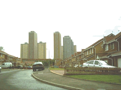
Just to be more precise about where they are, here's a Google streetview:


View Larger Map

There's also a series of Quicktime panoramas here (with further links on the right of this page). There's also a gritty/disturbing 2006 film of the same name which is set there. There are hundreds of other potential links, but the final one here is from a short BBC film of the area. The schedule for demolition is a little unclear, but the first block is supposed to be toppled in spring 2010.

Finally, I edited one of my very own Red Road photos (taken in 2005) to see what the skyline will look like from Petershill Road once they are all gone (the picture below is a small animated gif).

Friday 15 January 2010

Obama's Urban Policy in 2009

I've blogged before about Barack Obama's urban policy approach in the US and recently came across a video by the National Journal Online which reviews his progress over the first year. He gets about 4 or 5 out of 10 according to most, and the video has some interesting comments from Adolfo CarriĆ³n.

Friday 8 January 2010

GeoDa - for spatial data analysis

A quick post today on GeoDa - a piece of software for spatial data analysis, and also a centre for geospatial analysis and computation at Arizona State University. I've used the software for a few years and found it really useful, so thought I'd do a short post on it and a little video too, just to demonstrate what it looks like in action.

In the video I've not done any analysis or explored any of the capabilities with GeoDa, but rather just shown how the interface works and performed a couple of basic tasks, like adding a shapefile and making a basic choropleth map. The main thing I've used it for is measuring spatial autocorrelation in relation to deprivation in England but there are so many other uses and it is now very widely used (among spatial stats boffins at least!).

The version I'm demonstrating here isn't the only software that the GeoDa people produce - for a full list, see here. However, it is a very powerful tool for geospatial analysis and one that many researchers could not now do without...


Friday 1 January 2010

Regeneration 2000-2009

Much has been written about regeneration in the UK over the past decade. A couple of days ago I saw a piece in the Guardian about 'regeneration in the noughties'. Interesting stuff - basically, it says that a decade of regeneration has resulted in nice looking city centres but not a lot else. In particular, it looks at the experience in Sheffield. (For Sheffield, the Sheffield blog is also quite interesting.)

I wrote a blog post about this general topic ages ago but it's useful to reflect on the past decade since the new one looks like it will be all about public spending cuts and not much shiny new regeneration.