Showing posts with label population. Show all posts

Sunday, 25 January 2015

How many people live in Tokyo?

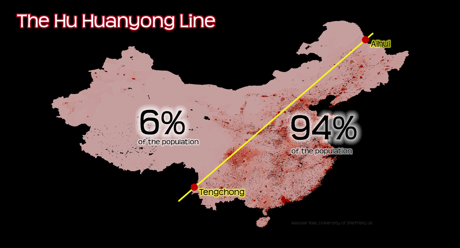
Back in August 2014 when I was preparing some material for teaching students how to query data in a GIS, I devised a very simple example where they had to select all the countries in the world with a lower population than the Tokyo Metropolitan Area (or Greater Tokyo Area, as it's sometimes called). I did this just as an example but since I found the results quite interesting, I quickly turned it into a map and posted it on Twitter, complete with 'Toyko' typo in the subheading. It was really just a quick example of how to query data in a GIS but it also highlighted the massive population of the Tokyo metropolitan area. You can find the full size, original image here. I was prompted to write this blog because the map was reposted on the Canadian Twitter feed @AsapSCIENCE a few days ago and since then my inbox has been a bit busy.


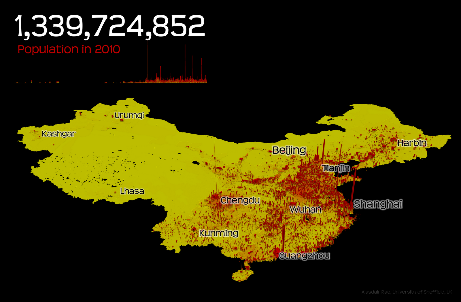
Now, back to the original question of how many people live in 'Tokyo'. Well, when I say 'Tokyo' in the map, I'm referring to the wider metropolitan area, which in 2014 the United Nations World Urbanization Prospects said has a total population of 37,833,000, far beyond the next largest urban agglomeration, Delhi, at 24,953,000. By way of comparison, using the urban agglomeration population (rather than a city's administrative boundaries), Toronto had 5.9 million, London had 10.2 million and Beijing had 19.5 million. Clearly, these definitions include other urban places that are not Tokyo (e.g. Yokohama) but they are recognized as being part of a fairly coherent metropolitan area. 

So, in the map, I'm using a figure of 'approx 36 million' as I say but in reality the UN figure is a bit higher. If we want to narrow the definition down to just the inner urban area then obviously the figure reduces significantly. I'm not usually one to cite Wikipedia, but in this case it's a good place to go to learn about the various definitions of the Greater Tokyo Area/Kantō region. If you don't want to click, here's a summary of some Tokyo populations...
  • Former city area (23 'special wards') - 8.95 million people
  • Tokyo Metropolis - 13.05 million
  • Tokyo Metropolitan Employment Area - 31.70 million
  • National Capital Region - 43.47 million
If we take the metropolitan definition used by the United Nations, then Tokyo does indeed have more people than Canada, at 35.5 million (2014 Statistics Canada estimate) and far more than Australia at 23.7 million (see their population clock). The Tokyo metropolitan population is roughly the same as the whole of California, which currently stands at about 38 million.

Link to chart

This was all just a little bit of map trivia and whilst it seems to have annoyed some people who live in a red country, the point was just to demonstrate the simple analytical power of GIS in addition to the size of Tokyo (to make it more interesting). The data I used are from Natural Earth if you want to have a look yourself and the software I used is a free GIS called QGIS, which is really good. Some other random facts about what happened to my original tweet...

Tokyo metropolitan area


Thursday, 13 November 2014

The Urban Fabric of Los Angeles

I've recently become a bit obsessed with looking at the urban fabric of different cities. I've looked at building footprints in English Cities, Scottish Cities, and collected data on a number of US cities, including San Francisco, New York, Chicago and Los Angeles. I've blogged and tweeted about this quite a bit over the past few months and the reason I'm so fascinated by it is that it provides some really interesting visual insights into the spatial structure of cities. I also find it fascinating to make visual comparisons between cities, as in my 'Urban Fabric of English Cities' blog post from October 2014. Now I'm going to look at Los Angeles. I've only been there once but I found it fascinating in so many ways (urban structure; fragmented political, social, racial geography; freeways; congestion; In-N-Out Burger...). Famously, Los Angeles is also the most populous of the 3,144 counties of the United States with a population of just over 10 million. The first image below shows all 3,000,000 or so buildings in LA county - all 4,000 square miles of it (for comparison, London is 607 square miles).

Los Angeles County - population 10 million (higher res)

Anyone who knows anything about American cities will understand that the concept of a 'city' and a 'boundary' is not necessarily as straightforward as it might appear - well, at least not to me as a British person. The City of Los Angeles is a rather odd shape and has a population of about 3.8 million. The image below shows the urban fabric (building footprints) for the City of Los Angeles.

The City of Los Angeles - population 3.8 million (full resolution)

Finally, I've produced a map showing the wider Los Angeles metro area (within Los Angeles County), with the urban footprint of the City of Los Angeles highlighted. The wider metro area extends beyond the boundary of Los Angeles County and has about 13 million people. What's the point of all this? Partly a mapping experiment and partly to illustrate the idiosyncrasies of political and administrative boundaries in urban areas compared to the underlying urban fabric. This is very acutely demonstrated in the case of Los Angeles.

The City of Los Angeles in context (higher res)

If you like these images and want them in higher resolution versions just get in touch via twitter - @undertheraedar or e-mail. I've linked to a high res version for the LA city map.

Data source: Los Angeles County - Countywide Building Outlines

Tuesday, 4 November 2014

Manchester: a "Northern Powerhouse"

The announcement yesterday from the Chancellor that we need a "Northern Powerhouse" in England was greeted with much enthusiasm - and also a good bit of cynicism, given that it's not far from the General Election. After the announcement, the BBC asked whether more English cities should be like Manchester. What I wanted to know was how this nascent northern powerhouse compared to the already established southern one (London, I think). We all know the numbers - well most do - but what about spatial scale, density and visual comparisons? Given a previous bit of mapping on the urban fabric of England and the fact that I've been thinking about the 'underbounded' nature of the City of Manchester (as opposed to the city region), I thought I'd go a bit further with this post.

The first image here shows how Greater London compares to Greater Manchester - they're mapped at the same scale - and I've also put the Greater Manchester boundary over Greater Manchester and vice versa, just to show that they're not that radically different in size.

Greater Manchester - a large urban area (higher res version)

I've also produced the same image without the respective boundaries overlaid on each city, just to provide a quick visual comparison at the same scale.

Click for higher resolution image

Finally, in order to demonstrate the way in which the City of Manchester is really 'underbounded' in relation to its wider city region, I've shown just the urban fabric of the City of Manchester (i.e. building footprints) in relation to the ten local authority areas of Greater Manchester, beside Greater Manchester as a whole. 

Click for bigger version

I have some even higher resolution images if anyone is interested - if so, feel free to get in touch via e-mail or twitter (@undertheraedar). I just wanted to produce these images to illustrate the fact that Greater Manchester is actually very big (about 80% of the size of Greater London in area) though of course has far fewer people (about 33% of the population). It does seem like the most likely 'northern powerhouse' in England and it will be very interesting to see how things pan out over the coming years.


Friday, 22 March 2013

The Highlands and London: lots of space vs. lots of people

I've been doing some work recently looking at local authority data from across the UK. One thing that always fascinates me about this is the differences between areas at a very basic level, such as the different sizes and populations of local authority and other sub-national areas. The two examples which always stand out in my mind are the Highland council area (because that's where I'm from) and Greater London (because it's so big and dynamic). The other reason the Highland council area stands out is because it is by far the biggest local authority in the UK. It's bigger than both Wales and Northern Ireland, yet it only has 232,000 people. London, on the other hand, would fit into the Highland council area about 20 times over yet it has 8.2 million people - as you can see from the map (click to enlarge - and see full screen here).


The map above shows Greater London and the Highland Council area mapped to the same scale, with London moved to the middle of the Highlands (not expecting this to become official Scottish Government policy any time soon, but you never know). Greater London is about 40 miles across but it is totally dwarfed by the Highlands. What is the relevance of all this? Well, it is interesting to think about this in the context of local government and the challenges they currently face.

Within Greater London you have 32 Boroughs plus the City of London all performing a variety of functions and in the whole of Scotland there are 32 Council Areas (which esteemed blogger Peter Matthews can list alphabetically off the top of his head). In the context of the ongoing fiscal crisis, there has been some talk of merging all local authorities in Scotland. I doubt it is going to happen but you never know. A Scotland on Sunday article on it from late 2012 seems to suggest there is some truth to the idea.


Monday, 26 November 2012

Population growth in Manchester city centre, 2001 to 2011

Manchester city centre experienced a population explosion between 2001 and 2011. In the area covered by the map below the population increased by nearly 400% - from 5,957 to 23,295; a rise of 17,388 people.  In 1991, the same area (roughly) had a population of 2,887, as you can see here. Anyone who knows Manchester will know about this but possibly not about the scale of the change. A lot has been written about these changes (e.g. Centre for Cities in 2006, Manchester Evening News in 2012) but it is clear that much of the growth experienced in Manchester has been driven by a new phase of city centre living. Click an area on the map to find out more about it and zoom in to the larger version of the Google map to see it in more detail.


But who are these new residents? Chris Allen, writing in 2006, said they might be a mix of 'counter-culturalists' from the new middle class, 'city centre tourists' from the service class and 'successful agers', who tend to be over 50. Whoever they are, they're living in the new apartment buildings that began to sprout in the perforated urban landscape of central Manchester over a decade ago.

The map above contains a total of 15 small areas known as super output areas. If you click on any area you can find out how many people now live in each. The map also tells you the total land area of each small parcel and how many households are in it. You can find more of this kind of information via the Guardian datablog and also by clicking through to the raw data on the ONS web pages. It was only released on Friday but I've been looking at it now because I'm writing a short paper on small area population change in the English core cities. Central Manchester has grown the most but other cities have also experienced rapid expansions.

A note for spatial analysts: the 15 LSOAs you see in the map above are new. They are just 15 of the 229 new LSOAs across the core cities and this makes change over time analysis a little more tricky. Manchester's total population growth during this period was just under 20% (or 80,000) so the growth in the centre accounted for just over 21% of the increase.

Sunday, 8 July 2012

How Big is Beijing?

I was in Beijing recently for a conference and was astonished by the scale and intensity of the city. I found it a little difficult to get my head round the sheer size of Beijing so I thought I'd do a little comparison between Beijing and London. 'Beijing' here refers to the municipality of Beijing (i.e. the Province-level city) and 'London' refers to the 32 Boroughs + City of London which make up Greater London. I've illustrated this in the graphic below, which maps Beijing and Greater London at the same scale. As you can see, Beijing is much bigger - both in terms of area and population.

Click here to see the full size version.

Key facts: Beijing is, area-wise, more than ten times bigger than Greater London. It has a population of 19.6 million, compared to about 7.8 million for Greater London. This comparison is of course not really fair because Beijing includes several large rural areas. A better comparison is to look at the Inner Districts of Beijing since these cover an area quite similar to Greater London (1,377 vs 1,572 sq. km. respectively). In this comparison Beijing has 11.7 million people compared to London's 7.8 million. No matter how you look at it, though, Beijing is 'big'! If you're interested in another comparison, take a look at Oliver O'Brien's comparison of Tokyo and London...

Monday, 11 June 2012

The Population of China

In a few weeks I will be travelling to China for a conference, where I'm co-presenting a paper on regional inequalities in China and the EU. This has meant I've had to get hold of lots of Chinese datasets, some of which I have produced maps from - so I thought I'd post one or two here, along with some facts and figures. I should point out that most of the data I've been using has come from the National Bureau of Statistics of China website. 

Higher resolution version

In this 3D map I've just extruded the surface using population density data at a very local level. This required a reasonable amount of computing power but the effect is simply to emphasise the significant West/East split in population within China. This geographical division has been the topic of discussion for a long time and in relation to a number of areas but is generally referred to as the Hu Huanyong line (also sometimes the Hu line, Heihe-Tengchong Line or Aihui-Tengchong Line), after the Chinese population geographer of the same name. Strangely enough, there is a Facebook page dedicated to the Hu line. The line divides China roughly into two parts. In 1935 when Hu first identified the split, the West had 57% of the area and 4% of the population. Today, the East has 94% of the population of China, but only 43% of the area. You can see how this looks in the map below... 


I'm still working on my parts of the presentation but am really fascinated by the facts and figures emerging from the 2010 Chinese census and data for different regions of China. China accounts for almost exactly 20% of the world population and both Beijing and Shanghai (i.e. the provinces) have 20 million or more people. I still need to learn a lot more about China, Chinese data and regional development there generally but my work so far suggests that patterns of regional inequality - while different in absolute terms - are often strikingly similar to patterns of regional inequality in Europe. A good example of this is in Jiangsu province, to the north of Shanghai.

Citations: Center for International Earth Science Information Network - CIESIN - Columbia University, International Food Policy Research Institute - IFPRI, The World Bank, and Centro Internacional de Agricultura Tropical - CIAT. 2011. Global Rural-Urban Mapping Project, Version 1 (GRUMPv1): Population Density Grid. Palisades, NY: NASA Socioeconomic Data and Applications Center (SEDAC). http://dx.doi.org/10.7927/H4R20Z93. Accessed 10 June 2012.

Balk, D.L., U. Deichmann, G. Yetman, F. Pozzi, S. I. Hay, and A. Nelson. 2006. Determining Global Population Distribution: Methods, Applications and Data. Advances in Parasitology 62:119-156. http://dx.doi.org/10.1016/S0065-308X(05)62004-0.


P.S. Thanks are due to Chunhua Liu for her insights here!

Thursday, 31 May 2012

Unemployment in Europe (via Google)

Despite recent headlines about data capture, Google remains an excellent source of (or gateway to) information on socio-demographic data. For example, if you type in 'population' followed by a country name, such as 'mexico' then this is what you'll get...


If you do this with any country you'll get the latest results plus a little graph which you can then click on and explore further. Similarly, if you type in 'eu unemployment' you will see a little chart showing EU unemployment - currently 10.2% for March 2012 - and how it has changed over time. If you click on the small chart you'll then see data for Europe and be able to add in data for other EU nations by clicking the boxes to the left. You can even embed this in a web page, as you can see below...


Apart from being convenient and accurate, this is also a very useful analytical tool when you need quick comparisons, like in the example below where I've compared Spain, the EU, Germany and Austria. As you can see the time-series data does not always extend as far back as we'd like but it is a great way to get your head round what is happening in different places without much effort at all. You'll notice in the embedded graphs that if you hover over a line it should tell you the data value for that point.


I've now changed the criteria in the chart so that it only includes unemployment for those aged less than 25 - and I've added in the UK too. This makes pretty grim reading for the EU, and Spain in particular...


This method also works for lots of other kinds of data. For example, if you type in 'us gdp' you'll see the data for the US but also have the option to add in lots of other comparators. One of the most interesting comparisons is looking at GDP over time, as you can see below.


I'm going to a conference in China at the end of June, hence my interest in national comparisons. This kind of thing has of course been covered extensively by Hans Rosling, but not many people know that it is fully integrated into Google's basic functionality.

Tuesday, 21 February 2012

Small Area Population Change in London, 2001 to 2010

Every ten years, data nerds in the UK get very excited by the prospect of getting their hands on new Census outputs. If you're lucky enough to be Canadian then you can get excited every five years but for many of us (Americans and Chinese included) it's the decennial Census that really does the trick. In the UK we can expect the first results in July 2012 according to this document. But what about in between Census dates? This is where small area data analysis becomes tricky. That's why the ONS publish mid-year population estimates for small areas in England and Wales. 

I've been looking at data for London again, so I thought it would be interesting to see which small areas have increased in population and which have declined in the period from 2001 to 2010 (the most recent data). Some map results below, but it is interesting that 11 areas (LSOAs) have more than doubled in population during this time. 


  • The 11 areas which have more than doubled in population are in Tower Hamlets (4), Greenwich (4), Ealing, Enfield and Hounslow
  • 85 areas have increased in population by 50% or more between 2001 and 2010
  • 344 areas have increased in population by 25% or more between 2001 and 2010
  • 5 areas have decreased in population by 50% or more - these areas are in Greenwich (2), Southwark, Brent and Newham
  • 19 areas have decreased in population by 25% or more during the 2001 to 2010 period.
Overall, the population of London has increased by hundreds of thousands between 2001 and 2010. According to the mid-year population estimates it has increased by approximately one Manchester in population terms (i.e. about 500,000 - equivalent to the City of Manchester population in 2011). That's about a 7% increase. 

The data are somewhat experimental but if we aggregate up to Borough level, then Brent and Newham both show losses (about 5% and 4% respectively) whilst City of London (60%) and Westminster (25%) show the largest gains.

This data for London - and lots more - can be found on the pages of the excellent London Datastore.

Monday, 9 January 2012

Daytime Population in the United States

My last post on London's Daytime Population is getting a lot of page views, which is nice, so I thought I'd do something else on the same topic. Although I do try to make nice images with data, there are some very important planning-related issues here. The first is just to do with the importance of knowing how many people live in an area. In New York City, the city challenged the 2010 results because it could have led to less federal aid, and in the UK in 2011 the city of Cardiff claims there was an undercount which could have led to them missing out on £85 million of funding since 2001. In relation to daytime population, this is also very important, but more difficult to calculate, as Robert C. Schmitt discussed in 1956. So, I looked at the 3,111 counties of the lower 48 states in the US and mapped them by daytime population density, as you can see below.


Why does it matter that we know what the daytime population of a place is? Well, there are many reasons including planning for public transit, traffic flow, infrastructure needs, utilities and even for developing evacuation procedures (Schmitt was writing in 1956 but perhaps this last point is still relevant today).

In the United States, the county with the highest daytime population density is New York County (aka Manhattan). It is far and away the leader in this category, with 126,100 persons per square mile. That doesn't quite match the daytime population density of the City of London but bear in mind that Manhattan covers 22 square miles! Manhattan's daytime population is also about 1.3 million more than its total resident population, which in 2010 was about 1.6 million.

Wednesday, 21 December 2011

London's Daytime Population

A couple of months ago I did a short post on the difference between daytime and night time populations in the North West of England. I've been interested in this for a while but some other recent work from the US got me thinking about it again. More recently, the London Datastore released data on London's daytime population for 2010 so I thought I'd take a closer look at the data and do something with it. The graphic below pulls out the most interesting data - not least of which is the fact that London's daytime population is 9.3 million!


I downloaded the data, explored it and did a little 3D mapping of population density. The daytime population density figures for the City of London are quite staggering (350,000 people per square mile!). During the day, the population of Westminster is nearly 1 million - compared to about 250,000 permanent residents. The City of London only has about 11,700 permanent residents but its daytime population is 390,000. If you're looking for the London Borough with the most prams, then head to Newham - it has the highest number of children aged 0-4. If you're looking for overseas visitors, head to Westminster where you are bound to bump into one of the 65,000 or so who are there. 

The data are very interesting, but also important. If we want to understand cities and how they work (and how to make them work better) then this kind of information is critical. 

That's all for now...

Thursday, 13 October 2011

How Big is London?

In studies of cities and urban areas, a common question that crops up is 'how big' a particular city is. I'd be inclined to answer this in terms of population, which for Greater London in mid-2010 was 7.83million. Most urban academics, however, are more pedantic and if you asked them how big London is, they might ask what you mean by 'big' and what you mean by 'London'. So, following the theme of some posts over the past year I decided to take a look at this purely in terms of the land area of some key UK 'cities'. I looked at the London Boroughs for Greater London, plus local authority areas for the English core cities, plus Edinburgh, Glasgow, Cardiff and Belfast. I then put them side by side at the same map scale and produced the following image...


The cities (i.e. the local authorities) in the image above are ranked by land area. London is the largest, at around 610 square miles, and Nottingham is the smallest at around 30 square miles. One issue when thinking about all of this is the extent to which most of the UK's cities are 'underbounded' in the sense that the core local authority area with the name of the city does not reflect the true extent of the functional urban area. Manchester is a classic example of this, whereas Leeds is more 'overbounded'. Tony Champion and Mike Coombes, among others, have written about this - e.g. in this presentation. In many ways this is quite a serious policy challenge, particularly when it comes to understanding and planning for wider metropolitan housing and labour market processes. But I'm getting carried away with myself now!

Finally, I thought it would be interesting to compare the areas in the image above to the UK's largest local authority by area. I did this because a) I'm from the Highland region and b) see reason a). The Highland region is, famously, about the size of Belgium and it is bigger than both Wales and Northern Ireland by some way. In relation to the latter, it is more than twice the size in terms of land area. However, in mid-2010 the total population of the Highland region was only 221,630. A final nugget of information: the Highland region is about 275 times larger than Liverpool. The image below shows the Highland region at the same scale as the areas in the first image. Perhaps we should all move up north and have more space! Or perhaps not.


P.S. The City of London is the smallest administrative 'district' in the UK, at around 1.1 square miles. 

Monday, 3 October 2011

Comparing Populations: Night Time vs. Day Time

Esteemed Canadian and fellow researcher Brian Webb, from the University of Manchester, recently sent me an interesting image which compares the population of Washington D.C. in the day to the population at night. This got me thinking. I did a bit of digging and found some of my old data. Put simply, I had two datasets for wards in the North West of England. One file contained the resident population of wards and the other had the population of wards during the day time (i.e. residents, minus out-commuters, plus in commuters). Out of this came two visualisations, as shown below (red peaks = more people) and a short video.


I also decided to turn this into a very simple animation, which is embedded below. I have also produced a larger version of this on its own page. Note: the video embedded below will keep playing once you click play. The larger version allows you to pause the video and watch at your own pace.

Unable to display content. Adobe Flash is required.

Although these are really just some pretty pictures there are some important points to be made here. We think about the population of places - and the associated local costs and constraints - in relation to resident population but in some areas the day time population is so high that the impact on the local area is far out of proportion to the size of the resident population. Another matter is the well known issue of spatial mismatch or, more generally, understanding the differences between where people live and where people work and the implications of this. 

In short, understanding the spatiality of populations is important for planning and policy purposes - these visuals are just a simple way of telling the story of data. This is important because the data on display here comes from an analysis of a commuting data matrix of 1000 x 1000, or one million cells of data. So, another point here is that data on its own is not information, as we all know.

Thursday, 8 September 2011

Comparing Populations: China, US, Europe

Since the US and China have both recently (2010) conducted a census I thought it would be interesting to look at some of the population results. Given the vastness of the US and China, I thought I'd do a little experiment and compare Chinese province populations with US states and European countries. I've put this data into a spreadsheet as well and also produced a map graphic comparing various areas. The purpose here is to highlight the large populations of so many Chinese provinces.


Some interesting nuggets from the data...
  • Guangdong province in China now has a population of 104 million, which is more than any European nation except Russia (141 million). The European part of Russia has 110 million. 
  • Poland, Shanxi province and California all have around 37 million people. 
  • Shanghai has 22 million compared to Romania at 23 million. 
  • Beijing and New York state both have about 19.5 million people. 
  • In total, ten Chinese provinces have a population of 50 million or more. The US and China have a very similar land area. 
  • Be honest, did you know that Anhui province has about the same population as Italy (60 million)?
Finally, some non-Chinese comparisons. Greece and Ohio both have a population of about 11.5 million and Michigan and Belarus are similar at about 9.5 million. Wisconsin and Denmark both have about 5.7 million people, and Finland and Minnesota have about 5.4 million. At the lower end of the scale, North Dakota and Montenegro both have about 670,000 people.

Friday, 8 July 2011

United States Census 2010

The 2010 US Census was conducted in April 2010 and already the results are looking very interesting. By the end of 2010 there was a new total population figure for the US, indicating a growth of 9.7% between 2000 and 2010. The total population on the twenty third US Census day was 308,745,538. This is just over double the total population from 1950. For a more up to date population estimate, you can check the US population clock from the US Census Bureau. Because I'm interested in all this, I've produce a graphic which shows population density and some population data for the lower 48 states, at county level. A couple of nuggets here: Los Angeles county has nearly 10 million people and Loving County (Texas) has only 82 people. All other counties lie somewhere in between...


Wednesday, 22 December 2010

The Size of Countries: USA and China

There have been a few blog posts elsewhere recently about the size of Africa. Kai Krause was the original blogger on this with his 'True Size of Africa' map, which is very impressive. This was picked up by a couple of other blogs, including the Economist's take on it and the Spatial Analysis blog at CASA.


I've recently been looking at this kind of thing from a different perspective but still in relation to the size of countries. Some of this has involved playing around with regions, nations and population data. I thought it would be interesting to look at the USA and China since they are very similar in area but very different in population.

Some images below. Click to view them full size. This first one puts the USA and China side-by-side with population data included and the second one superimposes China on the USA's land area.


Sunday, 14 November 2010

A Vision of Britain Through Time

I've been doing some work recently which involves the analysis of population change in England from 1801 to 2009. The data for this has come from the Census (which goes back to 1801) and mid-year population estimates (for 2009). The data itself has been sourced from a wonderful website called A vision of Britain through time, based at the University of Portsmouth. It's an innovative and pretty comprehensive exercise in historical stats and historical GIS.


As you can see from the screenshot above, you can enter a place name to find a place, you can look at various landcover maps, you can look at historical maps, Census reports and even travel writing by such distinguished contributors as Samuel Johnson, Daniel Defoe, Celia Fiennes and the wonderfully named Gerald of Wales.

Samuel Johnson's writing is from his 'A Journey to the Western Isles of Scotland' and is both shocking and funny seen from today's perspective. He very much disapproves of the 'Highland manners' and he calls Loch Ness 'a very remarkable diffusion of water without islands'.


The maps (as above) are really interesting and you can, for example, take a look at your area in the 19th and 20th centuries as well as look at the present day OpenStreetMap version.

To sum up, lots to look and and worth a look.

Friday, 22 August 2008

How Many People Live in Inverness?

Coming back to a familiar topic here - that of the population of places. It is interesting in its own right - see this site for information on everywhere, but it is also pretty important in terms of policy formulation, implementation and delivery. Examples include Manchester's missing 25,000, (which equates to £7.5m in funding) and Slough's undercount of new migrants from outside the UK (which also has relevance for the Inverness case). Inverness is where I'm from and it's grown pretty quickly in terms of population over the past 20 years in particular, but there's some doubt as to exactly how many people live there. Everyone has ideas about this - from more generous figures (giving a 'city-region' population of 66,000 in 2001) to figures for the 'city' itself - a rather more conservative 40,949. This just illustrates the inherent difficulties in defining the population of places that have no statutory boundaries. Even if that was the case, the difference between city populations and urban area populations is often very large, as in the case of Manchester (the district) and the Manchester city-region.

So, I've done a bit of analysis, as follows. I attached the data zones for the Inverness city area (core city plus Smithton, Balloch, Culloden and other bits here and there) to the data zones for which we have mid-year 2006 population estimates and come up with a population of 54,685. I make no claims that this is a definitive representation of the population if Inverness but it does give an idea of how many people live in the area shown in the image below showing the google map of the population of Inverness that I've created. [The map may take a moment to load over a slower connection and I may eventually move it off the server it's on right now so the link may eventually die, but the screenshot below is good forever.]

So, once and for all the question has been answered. Or has it?

Wednesday, 28 May 2008

How Many People Live in Manchester?

A quick post on a common urban theme. Answering the question of how many people live in a city is very tricky. Do you use the political boundaries of the local authority? Do you use the extent of the urban area? Do you use some other definition? In a completely unscientific experiment, I've developed a different approach - and it turns out that the populations I come up with are not that different to those given for the city-regions of the places on my list.

Here's what I did...
I took the eight core cities in England, plus London and chose the main central train stations in each of them as the central location (e.g. Lime Street in Liverpool). Then I used a bit of GIS wizardry to calculate the population within a 15 mile radius of said stations (statistically significant distance determined after much spatial analysis... and a bit off the top of my head). Here's the results (using ancient 2001 Census data):

Obviously, these figures differ a lot from the local political entities with the same names (e.g. Manchester the district has about 430,000 people). Even though I've used a fairly arbitrary technique, the populations are a much better reflection of the urban population than others often cite. So, let's compare the figures. On Census day in 2001 London had 7,172,091 people, Birmingham city-region had 2,693, 917, Manchester city-region had 2,482,328 and the other cities on the list show similarities to the 15 mile figure. What does this tell us? Not much really, except that if we use a 15 mile buffer from central train stations we get a good approximation of city-region populations for the major English cities. Here's how it looked on the map: